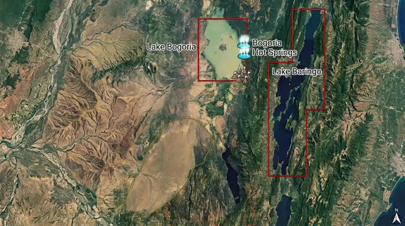
Satellite map of Lake Bogoria and Lake Baringo in Kenya's Rift Valley showing lake locations, Bogoria hot springs, surrounding terrain, watershed boundaries, and the potential hydrological connection corridor between the two lakes. Image Credit: Esri / Copernicus Sentinel data / NASA.
Africa
Lake Bogoria has crossed its spill point at 1,000.834m, leaving it less than 3km from Lake Baringo. Explore the science, risks, and Kenya's KSh 40B response.
Executive Summary
Kenya's Rift Valley lakes are converging rapidly, and the Kenyan government is racing to respond. Lake Bogoria has risen above its overflow level of approximately 1,000.2 metres, now reaching 1,000.834 metres. The distance between Lake Bogoria and Lake Baringo has fallen sharply, from about 20 kilometres to less than 3 kilometres.
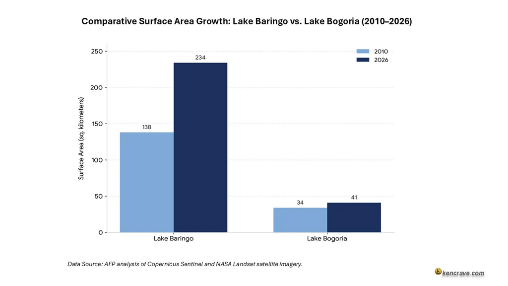
Since 2010, Lake Baringo has expanded by 70% and Lake Bogoria by 21%. This growth is driven mainly by a rise in intense rainfall days, which increased by 318% between 2010 and 2020 (Journal of Hydrology: Regional Studies, 2024). However, rainfall alone does not explain the change.
The risk is not only hydrological but also ecological and institutional. Lake Bogoria is highly alkaline and saline, while Lake Baringo is freshwater. A sustained connection between the two lakes could be dangerous. KWS Senior Warden Jackson Komen called this an "ecological disaster." Fish, crocodiles, and hippos could all be affected.
Already, about 380,000 people are at risk or affected. As of 2024, tourism revenue at Lake Bogoria National Reserve had fallen by 65% from its 2019 peak of Ksh 100 million. The education sector has been affected, with several schools closed due to rising water levels.
Kenya's response is a 40-billion-shilling engineering package. It includes a 5km dyke, a dam, an evacuation tunnel, a 40-kilometre canal, and an irrigation scheme. Whether it works depends on facts scientists have not yet confirmed.
There is no evidence on water volume crossing the Loboi Plain. A newly found groundwater seepage at Olkokwee raises further concern: the two basins may already be connected underground.
There is no evidence on water volume crossing the Loboi Plain. A newly found groundwater seepage at Olkokwee raises further concern: the two basins may already be connected underground.
Lake Bogoria Crosses 1,000.834m Spill Point: Baringo Merger Now Less Than 3km
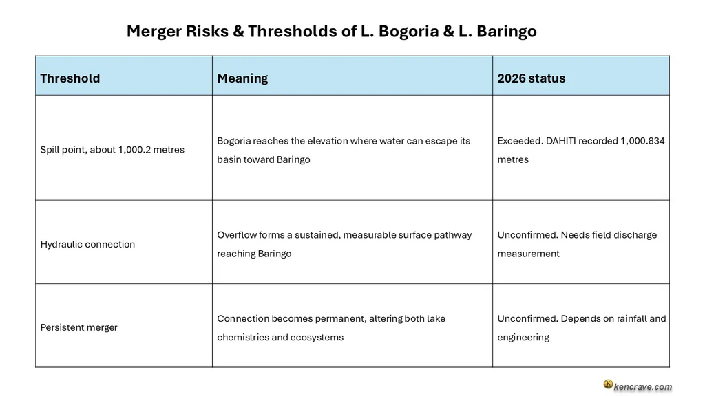
Lake Bogoria has already crossed its overflow threshold. Satellite altimetry shows the lake has reached 1,000.834 metres above sea level, exceeding the estimated spill point of about 1,000.2 metres (DAHITI, 2026). Scientists confirm the overflow is underway. The exact volume reaching Lake Baringo from Lake Bogoria is still unclear.
The key question has shifted. It is no longer whether overflow is possible. Three questions now matter most:
- What volume of water is crossing the Loboi Plain?
- How will Baringo's freshwater ecosystem respond to alkaline inflow?
- Can engineering interventions such as a dyke, tunnels, and canals prevent the lakes from merging?
Three Thresholds to Baringo Bogoria Merger: Spill Point Exceeded, Hydraulic Link Unconfirmed
Researchers track the merger risk through three thresholds. Kenya has already passed the first one.
Lake Baringo Grew 70%, Bogoria 21%: 96 Square Kilometers Added Since 2010
Several hydrological changes that have occurred in the L. Baringo and L.Bogoria basin between 2010 and 2026. Over this period, both lakes expanded in surface area, with Lake Baringo experiencing particularly dramatic growth and water level rise.
The comparison underscores the scale of landscape transformation and the increasing need for coordinated basin-wide monitoring and management to understand the drivers and consequences of these changes.
Lake Bogoria needed only about 0.6 to 0.8 metres of additional rise. That rise was above its 2020 maximum, which was enough to begin sustained overflow. The lake gained about 0.11 cubic kilometers between 2009 and 2014. It gained about 0.10 cubic kilometers between 2017 and 2020.
Why Rainfall Alone Can’t Explain The Rising Water Levels In The Lakes
Other factors could have resulted in rising water levels. One key factor is catchment degradation, which has worsened the problem. Sediment is filling the lakebed, meaning the same volume of water spreads over a wider surface. This amplifies shoreline flooding even without extra inflow.
Residents report that rivers Loboi (also known as Majimoto River) and Waseges have changed course. These rivers used to drain into Lake Baringo but now flow toward the saline Lake Bogoria instead. In response, residents have called for river diversions and the construction of upstream check dams to reduce erosion, slow runoff, and limit sediment delivery into the basin.
A new and unexplained signal has emerged at Olkokwee. In May 2026, water unexpectedly flooded more than 250 acres. There was no nearby river and no heavy rainfall. This may indicate that underground water pathways already connect the two basins. Monitoring should therefore include groundwater testing, not just surface water levels.
Lake Bogoria's Threatens Baringo Fish, Hippos
Lake Bogoria's highly alkaline, saline water could enter Baringo's freshwater system. KWS Senior Warden Jackson Komen has warned about the consequences. If the two lakes mixed, fish, crocodiles, and hippos might not survive. He describes this as a potential ecological disaster that would be difficult to manage.
Scientists and hydrologists track five core environmental variables. The severity of the crisis depends entirely on how these fluid factors interact across the Loboi Plain:
- Volume of overflow
- Duration: sustained flow determines dilution
- Chemistry: pH, salinity, and oxygen levels differ sharply
- Dilution capacity: Baringo's expanded volume provides some buffer
- Seasonality: dry season inflow concentrates the impact
The ecosystem is already suggesting stress. At Lake Bogoria, rising waters have driven away many flamingos. Flamingos at Lake Bogoria have declined from more than 1.5 million in 2019 to roughly 500,000 in 2025. This decline has affected the algae that flamingos feed on. Additionally, some hot springs have been submerged.
380,000 People Affected, 12 Schools Hit, Tourism Revenue Down 65% in Kenya
The overflow in Lakes Bogoria and Baringo has resulted in:
- About 380,000 people at risk or affected
- At least 600 households displaced in one area alone
- 12 schools affected
- Annual tourism revenue fallen from about $1 million US to $200,000 US
As noted by Agence France-Presse (AFP) and TRT Afrika 2026, at least four holiday resorts have been engulfed by Lake Baringo's waters. At Kokwa Island Primary and Junior School in Marigat, about 240 students and staff face daily risk.
They must take a ferry across a lake with crocodiles to get to school. KWS Senior Warden Jackson Komen reported that crocodile attacks have increased because the lake has moved closer to people's homes.
Infrastructure Losses: 26km Road, Reserve Gate, Ruko Conservancy Submerged
- Roads, schools, health facilities, and homes have been submerged.
- 26 kilometres of the Loboi to Emsos road, worth 15 million shillings, is submerged.
- The reserve's main gate and administration block, built in 2017–2018 at a cost of 30 million shillings, is submerged.
- Wildlife conservancies such as Ruko Conservancy, which protects endangered giraffes, face total submersion.
Lake Bogoria National Reserve's revenue has fallen 65% from its 2019 peak. The community's 10% equitable revenue share fell from 8 million shillings in 2019 to around Ksh 200,000 in 2024. Lake Bogoria Senior Warden James Kimaru estimates the reserve loses more than 100 million shillings a year.
The decline in revenues is attributed to the swelling of the lake, which has submerged roads, cut off access to the reserve's famous hot springs, and flooded out 90% of the geysers and surrounding tourist lodges. This ecological shift has also diluted the lake's salinity, forcing over a million flamingos to migrate away, further halting tourist traffic.
Kenya's 40 Billion Shilling Response To The Merger of L.Baringo and L.Bogoria
In July 2026, Kenya's Climate Change Directorate completed a Loss and Damage Assessment. In August 2026, a multi-agency team began processes to respond to the rising water levels.
The team included the State Department for Environment and Climate Change, the Kenya Defence Forces, the German Development Agency (GIZ), and the Kenya Red Cross. They assessed terrain, water availability, flood risks, and infrastructure needs. Their task was to develop a 90-day preparedness plan.
The Intervention Plan:
- 5-km dyke at Sandai: Physically separates the two lakes
- Dam on Waseges River: Controls inflow into Lake Bogoria
- 6-km evacuation tunnel: Moves excess water from Lake Baringo
- 40-km canal: Channels water toward Chemolingot and Suguta Valley
- Irrigation scheme: Diverts Baringo water to about 100,000 acres
Irrigation Principal Secretary Ephantus Kimotho said technical studies had confirmed one key point: only excess water from Lake Baringo will be abstracted. This preserves the lake's natural level and freshwater ecosystem. The project is expected to create about 100,000 direct and indirect jobs and generate an estimated 40 billion shillings for the economy.
Important limitation: Interventions in one part of the system may simply shift the problem elsewhere. For example, damming the Waseges River could further alter Lake Bogoria's water chemistry, potentially driving even more flamingos away. Any proposed intervention should therefore be preceded by a comprehensive assessment of its hydrological, environmental, and social impacts.
Four Future Scenarios on Merger of L.Bogoria and L.Baringo
A future merger between Lakes Bogoria and Baringo is highly uncertain and will depend on a combination of climatic conditions, hydrological processes, and human interventions. Changes in rainfall patterns, lake levels, and management decisions could produce a range of outcomes that is from a gradual reduction in flood-related risks to the creation of a long-term water connection between the two lakes.
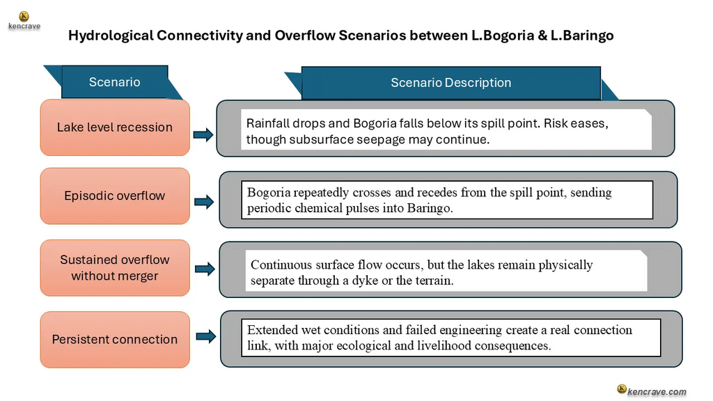
Professor Simon Onywere, a leading spatial environmental planner and researcher tracking the Rift Valley lakes, warned that the merging of Lake Baringo and Lake Bogoria is imminent stating it is simply a matter of time.
To safely manage this ecological risk, he recommended shifting strategy away from betting on a single outcome to focus instead on critical trigger conditions. Specifically, emergency protocols should activate once Lake Bogoria's water levels approach the Loboi Sill, the critical natural drainage divide.
What Scientists Still Don't Know: Overflow Volume, Chemistry, Groundwater Link Unverified
Scientists still do not know several key aspects of the potential overflow between Lakes Bogoria and Baringo:
- Whether a continuous surface water pathway currently exists between the two lakes remains uncertain and requires field verification.
- The actual volume of overflow water is unverified. A 2024 study by Herrnegger et al. notes the amount of water that may eventually reach Lake Baringo, and the extent of its impact, remains unclear.
- Whether overflow water is actually reaching Baringo or moving into surrounding wetlands before getting there.
- The chemical composition of any overflow water at the point where it enters Baringo has yet to be determined.
- How Baringo's freshwater ecosystems will respond to the introduction of alkaline water from Lake Bogoria.
Stakeholder Recommendations to Kenya's Government and Technical Engineers
Verify Overflow, Protect 380,000 People, and Sequence 40B Works
These recommendations are addressed to the key stakeholders managing the Baringo-Bogoria basin. They apply before, during, and after the 2026 El Niño rains and aim to shift the current approach from reactive emergency management toward proactive, verified, trigger-based basin governance.
1. Government Must Verify Overflow, Set 1,001.0m Trigger, Protect 380,000 People
Addressed to: Kenya's Climate Change Directorate, the Water Resources Authority, and the county governments of Baringo and Nakuru.
Satellite altimetry confirms lake elevation but cannot confirm whether a continuous water pathway exists. Discharge gauges, water tracers, and conductivity probes should be deployed on the Loboi Plain.
Lake level data should be published in near real-time to local authorities. An official early warning elevation threshold should trigger emergency protocols once Bogoria exceeds 1,001.0 metres.
2. Protect Communities at Risk Before the Rains, Not After
Addressed to: County disaster management units, the Ministry of Education, and the Kenya Red Cross.
About 380,000 people are already at risk. Twelve schools have already been affected. The most exposed schools should be relocated. Riparian boundaries should be marked. Emergency supplies should be pre-positioned ahead of the October and November rains.
3. Sequence the 40 Billion Shilling Works Around Verified Risk, Not Assumption
Addressed to: State Department for Environment and Climate Change, Kenya Defence Forces engineering units, and GIZ.
The Sandai dyke, the Waseges dam, the evacuation tunnel, and the irrigation canal are being planned as one package. However, constructing a dam on the Waseges River may modify the flow of water and dissolved materials into Lake Bogoria, potentially affecting the lake's chemical characteristics and ecological health. A full hydrological, environmental, and social impact assessment should be completed first not run alongside construction.
4. Redirect the Rivers That Communities Have Already Identified as the Problem
Addressed to: Water Resources Authority and county water engineers.
Residents report that River Loboi and Waseges have changed course toward Lake Bogoria. These rivers should be redirected toward Tiati and the Suguta Valley for large-scale irrigation. Upstream check dams should be built to reduce erosion and siltation. This is a lower-cost intervention that communities are already requesting.
5. Investigate the Olkokwee Groundwater Signal Before It Is Overlooked
Addressed to: Water Resources Authority, university hydrology departments, and satellite monitoring programmes such as DAHITI.
In May 2026, more than 250 acres flooded at Olkokwee despite no nearby river. This is the first evidence that the two basins might already be connected underground. Groundwater testing should be added to the basin's monitoring programme immediately.
6. Build a Permanent Observatory Rather Than a One-Off Assessment
Addressed to: Kenya Climate Change Directorate and the National Environment Management Authority.
A permanent Baringo-Bogoria observatory with automated monitoring should be established. A basin management authority spanning Baringo and Nakuru counties should also be established. Combined, these measures would replace sporadic assessments with continuous, trigger-based oversight.
Kenya's Baringo-Bogoria crisis is a test of sequencing. Monitoring, engineering, and community protection must be sequenced correctly to alleviate future disasters. They should not be sequenced after the next lake crosses its threshold.
The evidence so far shows real progress. Within months, the government moved from evaluating the problem to preparing a detailed engineering proposal with estimated implementation costs. But major unknowns remain:
- Officials do not know how much water is crossing the Loboi Plain.
- They do not know if it is reaching Baringo at all.
- They do not know if groundwater has already linked the two basins beneath the surface.
The lakes are converging. The real question is whether verification and engineering can move faster than the next disaster.
Key Takeaways
- Three thresholds define the merger. Spill point (crossed), hydraulic connection (unconfirmed), persistent merger (depends on rainfall and engineering).
- Five variables determine severity. Overflow volume, duration, chemistry, dilution capacity, and seasonality.
- The ecological collapse is already measurable. Flamingos dropped from 1.5 million (2019) to 500,000 (2025); hot springs submerged; algae food source disrupted.
- Infrastructure and livelihoods are being lost. 26km Loboi–Emsos road, the reserve's main gate and administration block, and Ruko Conservancy (endangered giraffes) are submerged.
- Scientists still cannot verify the overflow. Whether water reaches Baringo, its chemical composition at entry, and how Baringo's ecosystem will respond all remain unknown.
Frequently Asked Questions about Lake Baringo - Bogoria merger
1. Will Lake Bogoria and Lake Baringo merge in 2026?
Not confirmed. Bogoria has crossed its spill point, but a sustained surface connection to Baringo is unverified.
2. What happens if Bogoria's alkaline water enters Baringo?
Major ecological risk. Alkaline inflow could kill fish, crocodiles, and hippos, and disrupt Baringo's freshwater food chain.
3. What is Kenya doing right now to stop the merger?
A 90-day, KSh 40B engineering plan which includes a 5km dyke, Waseges dam, 6km tunnel, 40km canal, and irrigation scheme.
4. Is it safe to visit Lake Bogoria or Lake Baringo in 2026?
Check conditions first. 90% of Bogoria's geysers are submerged, four resorts are flooded, and crocodile attacks have increased.
5. How can I monitor Lake Bogoria and Lake Baringo water levels?
Use DAHITI or Kenya's WRA. Both publish satellite altimetry and field data. A permanent observatory is recommended.
Sources and References
This analysis draws on satellite altimetry data, peer-reviewed hydrological research, Kenyan government assessments, and field reporting from international and local news agencies.
- AFP / Africanews. "Kenya relocates crocodiles as rising waters bring them into conflict with humans." September 2026.
- AFP Analysis. "Copernicus Sentinel and NASA Landsat satellite imagery of Lake Baringo and Lake Bogoria surface area change." 2026.
- Citizen Digital. "Construction of 5km dyke between lakes Bogoria, Baringo to create 100K jobs, generate Ksh.40B." August 2026.
- Daily Nation. "Less than 3 kilometres: Inside race to stop lakes Bogoria and Baringo from merging." August 2026.
- Database for Hydrological Time Series of Inland Waters (DAHITI). "Lake Bogoria satellite altimetry record, 2002–2026." 2026.
- Herrnegger, M., Kray, P., Stecher, G., Cherono Kiplangat, N., Otieno, D., Olang, L., Nicholson, S.E. "Paleohydrology repeating? Regional hydrological change may lead to an overflow and cross-mixing of an alkaline and a freshwater lake in East Africa." Journal of Hydrology: Regional Studies, 2024.
- Kenya Climate Change Directorate. "Multi-agency 90-day preparedness plan for the Baringo-Bogoria Basin." August 2026.
- The Standard. "Plan to drain Lake Baringo targets 100,000 jobs, 100,000 irrigated acres." August 2026.