
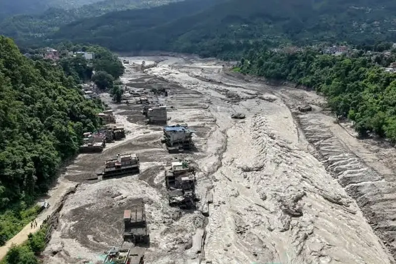
Aerial view of flood and mudslide devastation in Nepal, showing a river swollen with debris and buildings buried in thick mud after a 2026 flash flood disaster. Image Credits: Edunovations
Asia
Nepal-China flood 2026: 1,420 dead, 5,649 missing, $5B rebuild. Inside the avalanche that caused it, why warnings failed, and cross-border risks.
Executive Summary
Executive Summary
In August 2026, a massive ice and rock avalanche on the Langtang Lirung massif triggered a catastrophic flood that swept through Nepal and China. The flood resulted in the deaths of 1,420 people, left about 5,649 missing, and caused an estimated $4 - $5 billion in rebuilding costs.
The disaster exposed a critical monitoring gap, as existing warning systems were designed for monsoon floods rather than sudden ice-rock avalanches, and stations near the source were destroyed before alerts could be issued. With Nepal already carrying public debt at roughly 45% of GDP, recovery and disaster preparedness hinge on international support and climate justice appeals.
The event showed that mountain hazards ignore national boundaries, making cross-border cooperation and the rebuilding of risk-informed infrastructure essential to avoiding future losses.
The disaster exposed a critical monitoring gap, as existing warning systems were designed for monsoon floods rather than sudden ice-rock avalanches, and stations near the source were destroyed before alerts could be issued. With Nepal already carrying public debt at roughly 45% of GDP, recovery and disaster preparedness hinge on international support and climate justice appeals.
The event showed that mountain hazards ignore national boundaries, making cross-border cooperation and the rebuilding of risk-informed infrastructure essential to avoiding future losses.
Nepal-China Flood 2026: Key Devastation Figures
Note: Figures as of September 10, 2026
Source of key data points: Anadolu Agency
Source of key data points: Anadolu Agency
- Confirmed deaths, Nepal and China combined: 1,420
- People still missing, Nepal and China combined: about 5,649
- People rescued in Nepal: more than 13,656
- Estimated rebuilding cost: four to five billion US dollars
- Bridges destroyed: at least 19
- Road destroyed: nearly 40 kilometers
- Hydropower plants destroyed or badly damaged: more than a dozen
- Rise in the Trishuli river: about nine meters in thirty minutes
- Distance the flood travelled downstream: nearly 100 kilometers
- Security personnel mobilized in Nepal: more than 21,000
How a Mountain Collapse Killed 1,420 Across Nepal and China
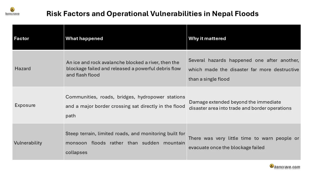
A section of glacier ice and the rock beneath it broke away high on the Langtang Lirung massif, at an elevation of about 5,200 meters. The mass fell into the upper Lhende Khola river valley, an area regional monitoring networks had not been watching closely.
The falling ice and rock gathered soil and debris and resulted in a temporary dam across the Lhende Khola. When that dam broke, it released a sudden and powerful flood. The flood travelled through the Bhote Koshi and Trishuli rivers, destroying roads, bridges, homes, hydropower facilities, and border infrastructure in both Nepal and China.
Rock Avalanche and Dam Break Caused Nepal's 2026 Flood Disaster
Nepal's disaster authorities suspected it was a glacial lake outburst flood (GLOF). Later assessments found that the disaster instead began with a large ice and rock avalanche that blocked the river.
Chinese authorities reached a similar conclusion, indicating a glacier fracture on the Nepali side triggered an avalanche that developed into a massive debris flow before reaching Gyirong Port.
The destruction of the Gyirong crossing shows how a local mountain hazard can become an international humanitarian and economic problem when critical infrastructure sits directly in its path.
This disaster led to a humanitarian and economic crisis. Gyirong Port serves as the primary land trade connection between Nepal and China. Its destruction immediately halted millions of dollars in bilateral trade, stranded hundreds of cargo trucks, and led to a complicated cross-border disaster response.
To understand the extent of the damage, this analysis examines three key factors: the natural hazard, the infrastructure's exposure, and the region's underlying vulnerabilities.
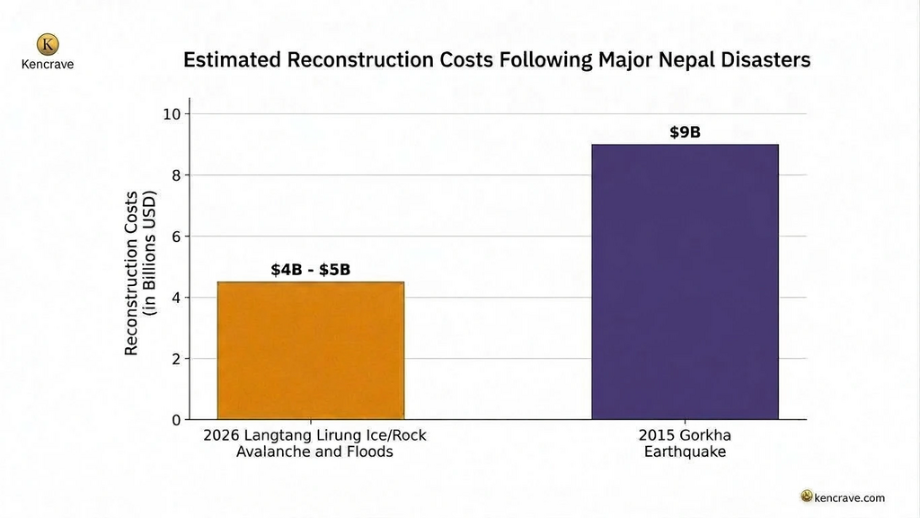
Nepal Flood Rebuild: $4–$5 Billion Needed as Debt Hits 45% of GDP
Nepal's Finance Minister Swarnim Wagle told Reuters on August 29, 2026, that the initial estimate for rebuilding is between $4 and $5 billion, roughly one-tenth of Nepal's entire gross domestic product (GDP). He further noted that this would likely be lower than the 9 billion US dollars Nepal spent rebuilding after the 2015 earthquake.
Rebuilding is a challenge for Nepal as it was already carrying significant public debt before the disaster. Nepal's debt is at around 45% of gross domestic product in mid-2026 (Nepal Rastra Bank, July 2026). This limits how much the government of Nepal can borrow and increases the importance of international support for rebuilding due to the disaster.
Nepal has also linked its recovery request to climate justice, noting that it has contributed relatively little to global emissions but faces high climate and disaster risk.
Monitoring Gap: Why Nepal's Flood Early Warning Failed
Early warning involves several steps: detecting a hazard, assessing the risk, sending a warning, communicating it, evacuating people, and responding. If any one step fails, the whole system becomes less effective.
Satellite images helped scientists understand the disaster after it happened, tracing the source area and the path of the flood. However, they could not explain in advance what caused the mountain to collapse. This indicates a monitoring gap, since existing water level sensors were mainly designed for normal monsoon floods, not sudden ice-rock avalanches.
Monitoring stations near the source were also destroyed before they could send a warning. Since the avalanche started on the Nepali side of the border, China's downstream systems had limited ability to detect it before the flood arrived.
Building an Effective Flood Early Warning System for Nepal
A stronger system should combine satellite tracking of glaciers and slopes, ground sensors for slope and glacier movement, river level and seismic sensors designed to detect sudden events rather than only normal floods, and weather monitoring for changing conditions.
That information then needs to reach people quickly through mobile alerts, sirens, radio, local authorities, and community-based warning systems backed by trained emergency response teams. The most important test is simple: can people receive a warning and reach safety before the disaster occurs?
Climate Change and the 2026 Nepal Flood: Is There a Direct Link?
According to scientists' reports, climate change may have contributed to the collapse of the mountain. Rising temperatures are changing glaciers and permafrost across the Hindu Kush Himalaya region, and unusually warm conditions were reported before the event. However, scientists note that more research is needed to determine whether climate change directly contributed to this specific disaster.
Cross-Border Flood Risk: Why Nepal and China Should Share Warning Systems
Mountain hazards do not stop at national borders. This disaster started in Nepal, affected China's Gyirong County, and then continued downstream back into Nepal. Both countries were affected by the same chain of events.
Rescue teams from Nepal, China, and India all contributed to the response, showing the value of international cooperation. A key lesson from the disaster: a warning system should not stop at a national border when a hazard can cross it within minutes.
Key Recommendations: Cross-Border Flood Monitoring and Resilient Rebuilding
- Governments of Nepal and China: Establish real-time shared monitoring of glaciers, slopes, and rivers upstream of avalanche source areas, including joint satellite and sensor data exchange, so hazards originating on one side of the border trigger immediate warnings on both.
- Nepal Government and Infrastructure Planners: Rebuild roads, bridges, and hydropower stations to withstand debris flows and sudden surges. Relocate the highest-risk facilities away from narrow river corridors wherever feasible.
- Research Institutions and Both Governments: Conduct joint Nepal-China studies of the Langtang Lirung slope and wider Himalayan permafrost changes, while installing sensors designed to detect sudden ice-rock avalanches and river blockages rather than only monsoon floods.
Rebuilding for China and Nepal After the 2026 Flood: Same Risks or Safer Future?
The scale of loss from the disaster was shaped by exposure, vulnerability, infrastructure choices, preparedness, and cross-border coordination, all of which can be improved before the next event.
The real test facing Nepal and China is whether recovery funding goes toward rebuilding the same infrastructure in the same locale or toward safer roads, bridges, and hydropower stations, stronger monitoring, and a warning system that can cross the border as quickly as the hazard itself. Rebuilding everything exactly as it is, could recreate the same risks. Building back differently is the harder but safer choice to alleviate similar disaster scenarios in future.